BWCAW Adventure 2006 — Angleworm Trail
This trail is a 13-mile loop mostly circling Angleworm Lake, which is located a few miles north of Ely, Minnesota.
| Guidebook: | John Pukite, Hiking Minnesota, pp. 90-92. Falcon Publishing, 1998. 1st ed., 3rd printing. |
| Map: | McKenzie #11, 2005 ed. |
What is an angleworm, anyway? (This may be the first hint that we are not native Minnesotans.) According to Webster’s, it’s a “terrestrial worm that burrows into and helps aerate soil; often surfaces when the ground is cool or wet; used as bait by anglers”. Gross! We didn’t see any. However, Angleworm Lake is long and skinny; perhaps it was named for the little critters? Other nearby lakes that seem to look like their namesakes include Boot Lake, Gun Lake, Fairy Lake, Thunder Lake, and, of course, Ritual Lake.
Day 1, August 30
We had driven up from the Twin Cities the previous day, visited the Soudan Mine Underground State Park, and camped at Pfeiffer Lake campground a few miles west of Tower. (We stayed in #8, which was pretty good. #10 looked to be the best site.)
We woke to the rattle of heavy machinery. Seems that they were building a new outhouse, or, more accurately, digging a giant hole that the new outhouse — which was waiting patiently on a flatbed semi — would sit upon. Breakfast was whole-grain hippie cream-of-wheat, which was spectacularly non-instant and fairly unpleasant without proper cooking.
After packing up, we drove to Ely, did some last minute shopping, and purchased a permit at the ranger station. We then proceeded to the trailhead and discovered, to our dismay, that we had left tortillas, bagels, and peanut butter at home!
![[p/img_0594.jpg]](p/img_0594.jpg.medium)
|
Reid and Erin at the trailhead. |
Fortunately, however, we were able to repurpose some pita bread and started hiking in at about 1:00 PM. Lunch was on-trail not too long after: salami with herbs, pitas, and cream cheese — very good.
![[p/img_0597_joined.jpg]](p/img_0597_joined.jpg.medium)
|
|
First vista of the trip, a fine view of Angleworm Lake. |
We were in camp by 4:00 or 4:30. We stayed at the northernmost campsite on the east side of Angleworm Lake (note that this and several other campsites are missing from the guidebook); we debated whether to go on to Whisky Jack Lake but decided to stay and relax instead. This turned out to be a good idea, as the campsite on Whisky Jack is only pretty good, while where we stayed was fabulous. We went swimming and lounged around a little.
![[p/img_0612_joined.jpg]](p/img_0612_joined.jpg.medium)
|
|
Camp on Angleworm Lake. |
Supper was macaroni and cheese with fresh tomatoes and dried veggies. We cooked 1-1/2 boxes, and it was plenty and quite tasty.
![[p/img_0617_joined.jpg]](p/img_0617_joined.jpg.medium)
|
|
Lake view from camp, shortly after sunset. |
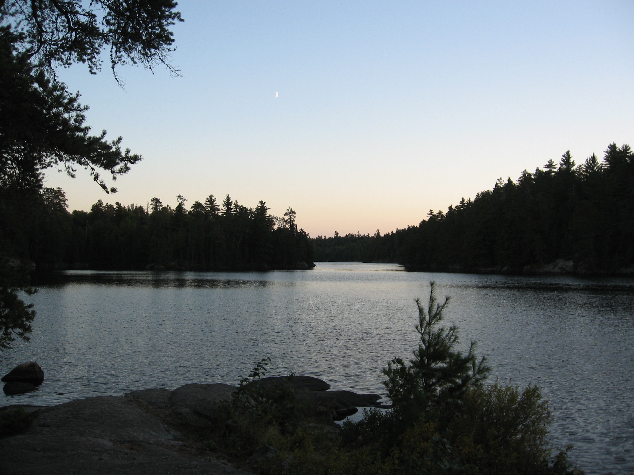
![[p/img_0629.jpg]](p/img_0629.jpg.medium)
|
Moonrise on Angleworm Lake. This photo was used on the cover of a mystery novel, Envy the Night by Michael Koryta. (I received a flat fee, so it doesn’t matter to me if you buy the book.) |
After supper we built a fire and Erin had hot chocolate while Reid had hot Tang. We had a mouse who was adorable and not very timid, but very few bugs all day. We looked at the stars a little and then went to bed.
Day 2, August 31
![[p/img_0631.jpg]](p/img_0631.jpg.medium)
|
Erin pumping water in the morning. |
We slept in and were on the trail by 11:15. The first landmark was the Whisky Jack Lake campsite, which was pretty good. After that, the trail went over some high points with some very fine views of meadows and Gull Lake in the distance.
![[p/img_0011.jpg]](p/img_0011.jpg.medium)
|
Me checking the map at a viewpoint east of Home Lake. |
Between Whisky Jack and Home Lake, we found some faded pink flagging tied to some trees, with grim-sounding notations like “shoes and jeans 20 yards south of trail” and “jacket stuffed under rock, 10:30AM, 6/21/05”. We asked later at the ranger station. Apparently, they were left over from an unsuccessful search and rescue the previous year, and the rangers suspected that the lost person hadn’t wanted to be found...
The campsite at Home Lake is, unfortunately, kind of a dump. It’s in the middle of the woods and doesn’t have any lake view, and it’s a few hundred yards from the campsite down to the water (mostly via canoe portage).
Looking for a lake view, we stopped for lunch on the Home Lake side of the Home-Gull portage. Shortly after we sat down, a couple of canoeists arrived and dry-footed their gear onto the portage. It took them a little while to notice us back in the bushes, and we exchanged a few pleasantries. (They wanted to know, “Is this the portage?”) They took quite a while to get combobulated and go on their way.
After lunch, the trail crosses a creek draining Home Lake and begins to climb. The guidebook notes an old-growth stand of red and white pines which is “one of the best stands in the state”, but we didn’t see anything of the sort. There are, however, some fine views northward into an unexpectedly huge, tree-filled bowl.
Contrary to the map, the campsite on the west side of the lake (just west of the marking “10” on the bathymetric contour) is not on the water. We didn’t look at it, but we saw the trail leading off into the woods away from the lake. There is an open area suitable for a nice, break, though, right across from our camp this morning. If you were ambitious, you could cut off four hours or so of hiking and just swim the 50 yards!
![[p/img_0635_joined.jpg]](p/img_0635_joined.jpg.medium)
|
|
Angleworm Lake. Note our campsite across the water and Erin in the non-campsite at the right end of the photo. |
We also solved a mystery here. The previous night, we had seen a yellow sign on a tree along the trail here, but even with Erin’s binoculars and lots of speculation, we couldn’t make it out. It turned out to mark something township/section/range related — boooooooring!
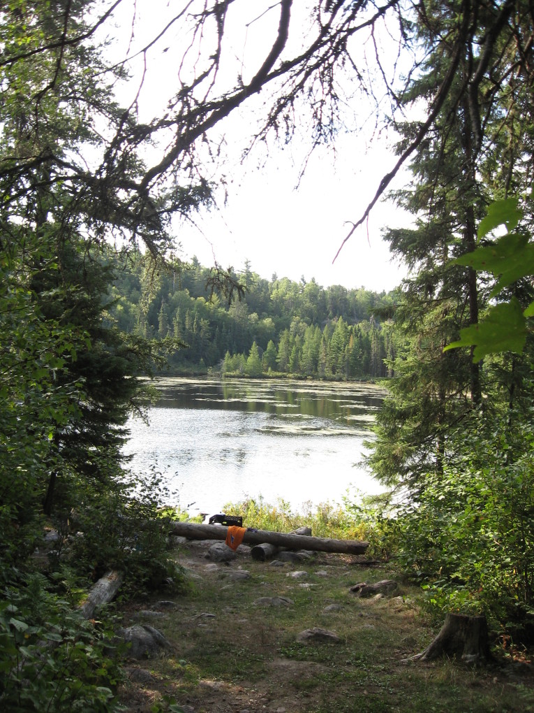
South of here, the trail follows the shore of Angleworm Lake, and there are repeated fine views of the lake.
![[p/img_0647.jpg]](p/img_0647.jpg.medium)
|
Angleworm Lake from its west shore. |
Near the final descent, a lookout tower is marked on the map. The guidebook says it’s a “former fire tower” and implies that there should be something visible from the trail, but we saw nothing. I’d be curious in hearing from anyone that found it; I think it would be just a matter of locating the highest point on that rise.
At the south end of the lake are three campsites. The book says that they are “along the water’s bedrock edge”, but only one is actually on the water. The real story:
- Too in the woods
- Too on fire
- Just right!
We didn’t look at the first (northernmost) site, but we saw its trail leading off into the woods, away from the lake. We ended up staying at the third site, which was quite nice, though the end of the canoe portage is only a few yards to the south — however, at 716 rods, this is probably only a problem on very busy days like the first day of Labor Day Weekend.
The second campsite was a bit of an adventure. When we turned down the path leading towards it, we thought it was occupied. We smelled woodsmoke, and as the bushes parted, we could see camping gear — a large pot, two mugs, and a small shovel.
But, there was no one around, no canoes, no other gear. There was, however, a fire smoldering away in the duff which had reached several feet away from the fire pit! We yelled “Hello!” a couple of times, but no one responded. So we put the fire out! We dug up all the burnt duff and made several trips down to the water, which was a significant scramble down and up the rocks. It was very exciting!
![[p/img_0649.jpg]](p/img_0649.jpg.medium)
|
Second campsite after our firefighting efforts. Note the charring on the log at lower-right; after not too much longer, the fire would have been out of the campsite and into the thick debris and bushes of the regular forest. Incidentally, this campsite seemed pretty nice, though the third has better lake access and views. |
We arrived in camp around 5:30 after another day of fine weather (just a few more clouds than the previous day). I had a small adventure setting up the bear rope: after stomping through the bushes, which were head-high, I managed to get the rock I was using for weight stuck in the tree. I overestimated the amount the rock would drop if I pulled hard on the rope and managed to bash myself directly in the shin. Ouch.
Also, someone had gotten a multitool holster on some parachute cord stuck on a lower branch. I was able to bat at it with a stick enough to feel that ther was something inside it, and I got very excited. Not only were the canoeists really idiots (there was a lot of trash in the fire pit at this site) to get their tool stuck in a tree, but Erin had lost hers at home and I could be her hero bearing a new one from the woods.
Alas, it was not to be. After a great deal of effort with the stick and bark in my eyes, etc., I managed to bring it down — but what was inside was rocks, not a fancy leatherman tool. I suppose those canoeists aren’t so dumb after all.
![[p/img_0012.jpg]](p/img_0012.jpg.medium)
|
Our friendly rodent neightbor snurfling away in our food bag before one of the many times we shooed him off. Clearly he knew how to leverage cuteness into food. He was nearly fearless and was totally unfazed by items thrown at him. |
Another pair of canoeists glided by during supper (red beans and rice, 1-1/2 boxes), and not too long after, we headed for bed, but not before a mouse ran across Erin’s foot with tiny, cold paws and she shrieked.
Day 3, September 1
We were awakened very early in the morning by our squirrel leaping about in the trees and pelting the tent repeatedly with small pine cones. He seemed very determined. Erin deduced later that since we hadn’t given him any food the previous night, he must have assumed that we were out and wanted to share some of his.
We were awakened again around 7am by some canoeists noisily putting in their canoes at the end of the portage, which seemed to be just a few feet away through the bushes. They must have been up pretty early to have finished the two-mile portage by that hour.
Finally, we crawled out of bed for good at perhaps 9am. More canoeists went by as we were eating breakfast (cream of wheat again, but instant this time), and these fellows embellished the banging of their canoes by screeching back and forth between the boats about something I’ve forgotten. (It was Friday morning of Labor Day Weekend.) We were on trail by 10:45ish and out not long after 11:30.
![[p/img_0654.jpg]](p/img_0654.jpg.medium)
|
Camp on the morning of Day 3. |
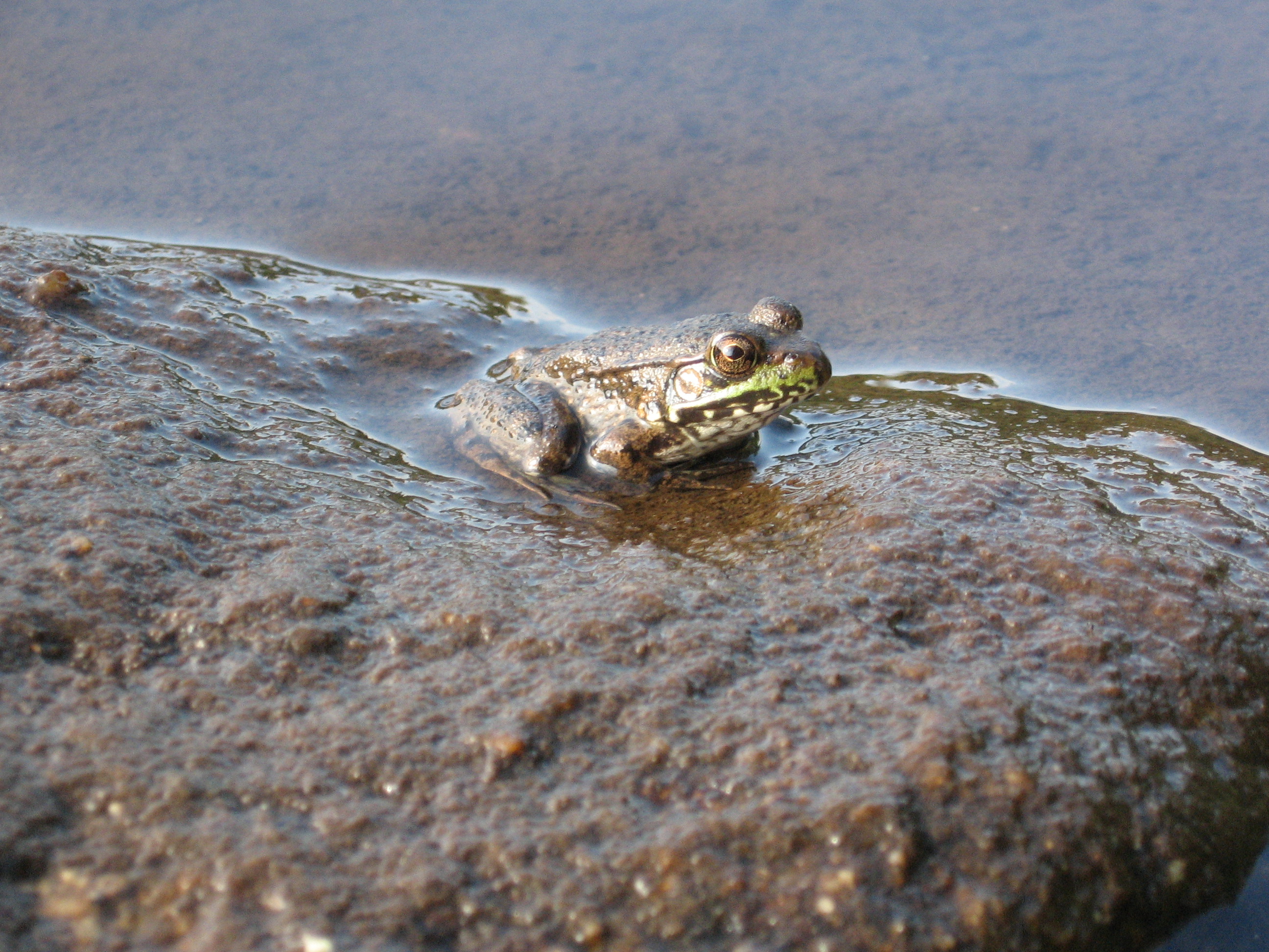
![[p/img_0651.jpg]](p/img_0651.jpg.medium)
|
An adorable frog in camp on the morning of Day 3. |
![[p/img_0657.jpg]](p/img_0657.jpg.medium)
|
Erin hiking out from Angleworm Lake. |
Next up was a trip to town, for groceries, lunch, and a new permit for the next leg of our adventure. When we stopped at the ranger station, we told the very friendly ranger — Maggie W., say hello if you see her — about the fire.
After that, we headed south of town, stopping to eat our sandwiches on the banks of the Kawishiwi River. It was time for our next adventure.
Please continue reading on Pow Wow Trail.